

Taming The Short Hills: An Elusive History
Since coming to work at The Brown Homestead, Director of Community Engagement Sara Nixon has been enamoured by the Short Hills. Overlooking the boundary provincial park at her desk, she’s often wondered about the stories tucked away in its forests. As she’s journeyed into this research, Sara has come to learn that the relatively young treescape seen from Pelham Road and its quaint moniker of the “short” “hills” do not accurately reflect the 200+ years of attempts to harness and tame its rugged wilderness. Read along to discover the stories hidden in the hills, valleys, and winding creeks of the Short Hills.
In an 1972 archaeological report to the Ontario Ministry of Natural Resources, Daniel M. Sothers writes that the Short Hills’ “hillslopes between the creek bottomlands and the upland ridges and hills are precipitous and inhospitable.” [1] This description seems to encapsulate humans’ relationship to this particularly undulated pocket of wilderness in Niagara’s otherwise quite advantageous landscape for much of history.
The origins of this cutesy name are a bit murky. The field notes of surveyor Thomas Welch in 1795 use the term “Short Hills” to describe the irregularity of the land. [2] This usage may have first been popularized by the settlers of the area, referring to the uneven terrain of the land they ploughed. By at least 1815, the area was formally referred to as the Short Hills, appearing on a post-War of 1812 map and indicated by the ever-so-subtle illustration of rolling hills.
Map of the Niagara District in Upper Canada, 1815. Note that the orientation of this map is facing south. Library and Archives Canada, NMC 21587. Digitized by MDGL, Brock University.
A decade later, in his 1825 Report on the Defense of Canada, Major-General James Carmichael- Smythe described the area by stating that “This high ground, is however occasionally undulated, one part is so much so as to have obtained in the country the name of the Short Hills.” [3] These early references suggest that from the time United Empire Loyalists began to move inward and settle the interior of Niagara in the 1780s and 1790s, inhabitants were made quickly aware of the elusive qualities and challenges this pocket of hills, valleys and streams presented to them. The historical records available present a curious cycle of people continually trying, and failing, to overcome the rugged wilderness at the heart of the Niagara Peninsula. Read on to uncover only the surface.
Attempts to Settle the Short Hills
Some of the earliest evidence of human activity in the Short Hills dates back to the Archaic period between 5000 - 300 B.C.E. Sothers’ 1972 archaeological survey found small chert flakes on a hilltop near the present day St. Johns area that was believed to be a “chipping station”, where weapons like knives, spears and arrows would have been shaped and sharpened. [4]
Later Indigenous peoples known to inhabit Niagara up until the mid-1600s were the Iroquoian-speaking Attawandaron, named the Neutrals by Jesuit missionaries. While the Attawandaron may have travelled the Short Hills to hunt and fish, they were more inclined to choose flat, sandy, upland regions to make home in more permanent settlements. [5] Opting instead to be closer to larger bodies of water, here they planted maize. The Attawandaron were also known to make ceramics - which, it is worth noting, was not found in the survey at the Short Hills. [6]
So it seems that sustained efforts to settle the Short Hills would not commence until the arrival of the United Empire Loyalists into the 1790s. But even then, the Loyalist families who settled at its edges did so based largely on speculation. They were drawn to the potential its hills and winding creek could provide - and perhaps underestimated the challenges of the terrain.
John and Magdalena Brown and their young children were one of those hopeful Loyalist families. Fleeing to Fort Niagara during the American Revolution, by the mid-1780s they chose to head into Niagara’s interior to rebuild their lives, settling along an established thoroughfare crossing the peninsula along the brow of the escarpment. They saw agricultural potential in the expanse of flat, fertile land to the north, and to the south an undulating landscape crisscrossing with creeks and streams. Where they build their family farm would become The Brown Homestead on Pelham Road in St. Catharines. Of the 700 acres of land granted to the Brown family for their loyalty to the British Crown, 600 acres were in the Short Hills, as depicted on the map above. To learn more about the evolving lands of the Homestead, check out our Mapping The Brown Homestead digital exhibit.
When we think about the economy around the Short Hills now, we might think mostly of agriculture: pastures, orchards, and even a few vineyards. But records indicate that the Short Hills nurtured a significant milling industry in the very early days of settlement.
A 1792 Surveyor General’s Report documented four mills operating on the Twelve Mile Creek around the Short Hills: a saw mill at the south-west corner of Grantham (we know the area now as Power Glen), a grist mill in Effingham, another saw mill in St. Johns, as well as at the top of Decew Falls. At the time, Loyalists were mostly concerned with clearing the land to build their homes, hence the initial demand for saw mills, and establishing their farms. At first, families grew maize due to its resiliency and relative ease. Eventually, settlers diversified their crops; growing wheat, barley, oats, buck wheat, beans, peas, and potatoes also. [7] Wheat was above all the most important crop and grown in the greatest quantity. As more crops were planted, the demand for grist mills increased and more popped up along the creek. By 1815, there were records of at least 5 saw mills and 6 grist mills operating in the area. [8] St. Johns had the largest enterprise, with John Darling also operating a woolen mill, iron foundry, brickyard and tannery. [9] All fully relied on the water power of Twelve Mile Creek.
Beyond agriculture and manufactories, inns and taverns are also established, including Swayze’s Inn in Effingham, Overholt’s Tavern in St. Johns, and Brown’s Tavern on Pelham Road (that’s us here at the Homestead!). Taverns not only served travelers, but were also vital gathering places for locals to meet.
General locations of the early communities of the Short Hills, overlaid onto an 1827 map of Niagara. Note that these settlements established themselves around the edges of the Short Hills, unable to access its interior. Note also the route of the still-mid-construction Welland Canal connecting Lake Ontario at 12 Mile Creek to the Welland River. Library and Archives Canada, NMC-21588. Digitized by MDGL, Brock University.
These flourishing communities played a vital role in supporting the surrounding economy. Farming families like the Browns would have relied on these nearby mills for their own livelihoods and the industries attracted both business and workers. That is, until the opening of the Welland Canal in 1829. Much debate and planning went into determining the route of the Welland Canal connecting Lake Erie to the south and Lake Ontario to the north. The interests of its investors were also heavily considered. The unruly hills and valleys of the Short Hills made it impossible to build a shipping way, so the interests of industrial centres like St. Johns were overlooked. For some communities, like at Decew Falls (whose founder John Decew was an early investor in the canal), water power was diverted away from their mills and the local industry suffered a direct blow. For others, business interests were simply redirected towards the more enticing opportunities of the canal and the milling establishments forgotten. At St. Johns, for example, the tannery, brickyard and many mills begun by John Darling all closed by the 1850s. Despite the investments and efforts made, the Short Hills proved too unforgiving. This sowed a peculiar seed of discontent among the communities that endured on.
Attempts to Fortify the Short Hills
But the same terrain that made the Short Hills unfit for commercial interests had great potential for military interests. After all, the development of the Welland Canal took place in face of the shadow of the War of 1812 and its aftermath. While its men would have been called to serve, the Short Hills itself was largely protected from the warfare thanks to its impenetrable terrain and lack of roads. It was physically impossible for an invading army to move through the area.
However, not all of Niagara enjoyed such fortunes. Battles and attacks were suffered all over the Niagara Frontier, including nearby at the Battle of Beaver Dams in June 1813. The communities of the Short Hills, and no doubt all of Niagara, lived in fear of violence and invasion at their doorstep. I can’t help but think of Loyalist families like the Browns, with the American Revolution and the turmoil of their fleeing still within lived memory. The War of 1812 certainly realized the fear which played on the minds of settlers and their colonial officials: one day America would turn its sights on Canada. And they could do so again. So following the War of 1812, significant efforts were made by the British colonial government to implement a defended border between Canada and the United States. And the Short Hills was championed as part of this new proposed defense system.
It was largely agreed that if Montreal, Kingston, and the Niagara Peninsula were fortified, then the defense of Canada would be secured. Since there were already forts established at Fort George, Queenston, Chippawa, Fort Erie and Mississauga - all along the Niagara River from Lakes Eries to Ontario - it was recommended that a fortification be erected in the central interior of the Niagara Peninsula. Since the Short Hills was immune to invasion during the war, officials saw it as perfectly positioned.

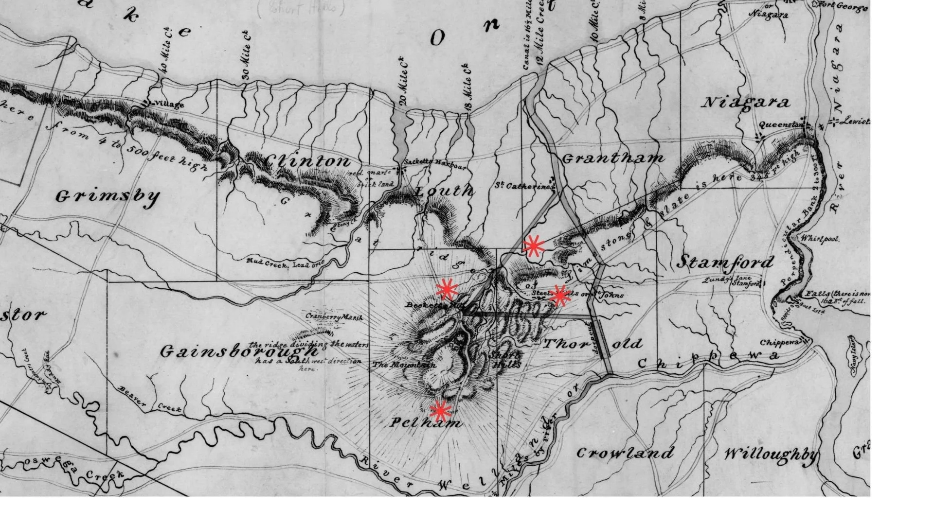
Map of Short Hills showing relief features and outline of proposed fortress, 1827. Library and Archives Canada, NMC 22145. Digitized by MDGL, Brock University.
In 1825, Sir James Carmichael-Smyth was appointed to develop the best plan to implement the colony’s upgraded defenses. Carmichael-Smythe scouted the Short Hills and suggested a location for the fortress about two miles west of St. Johns, on Twelve Mile Creek. From the hilltop, rising 120 feet high, he wrote that “Both Lakes can be seen from this Spot” and for that reason, “We never saw a site in our opinion, more eligible in every point of view.” [10] Erecting a military fortification here would eliminate the chance of a surprise attack, as the enemy could not move towards Hamilton or Toronto without being spotted, and would reduce the number of troops required for defense.
The site would be named Wellington Heights, after the British war hero the Duke of Wellington. By 1827, maps and plans were drawn, negotiations to obtain the land were written up, and in some cases property was even purchased. But then, it stalled. And delayed. The government simply didn’t want to commit the funds and effort.
The Upper Canada Rebellion of 1837 and the following skirmishes of 1838 (including a failed raid on the Short Hills itself, a story that requires its own dedicated journal article!) reanimated discussions on building Wellington Heights. These talks resumed through the 1840s. But ultimately, nothing ever came of the defense plan. Taming even a piece of its rugged terrain for the protection of Canada still proved to be too much.
Conceding to its Wildness
Life moved on. Over time, people forgot about the bright promise the early mills and businesses brought to the Short Hills, and the very real plans for a military fort began to seem incredulous. Some families remained in the area, but the communities did not grow as they were first positioned to. Instead, pockets of agriculture and winding roads emerged where it was feasible. Even as technology and machinery advanced, those that settled could only do so much in the face of its deep valleys and unrelenting hills.
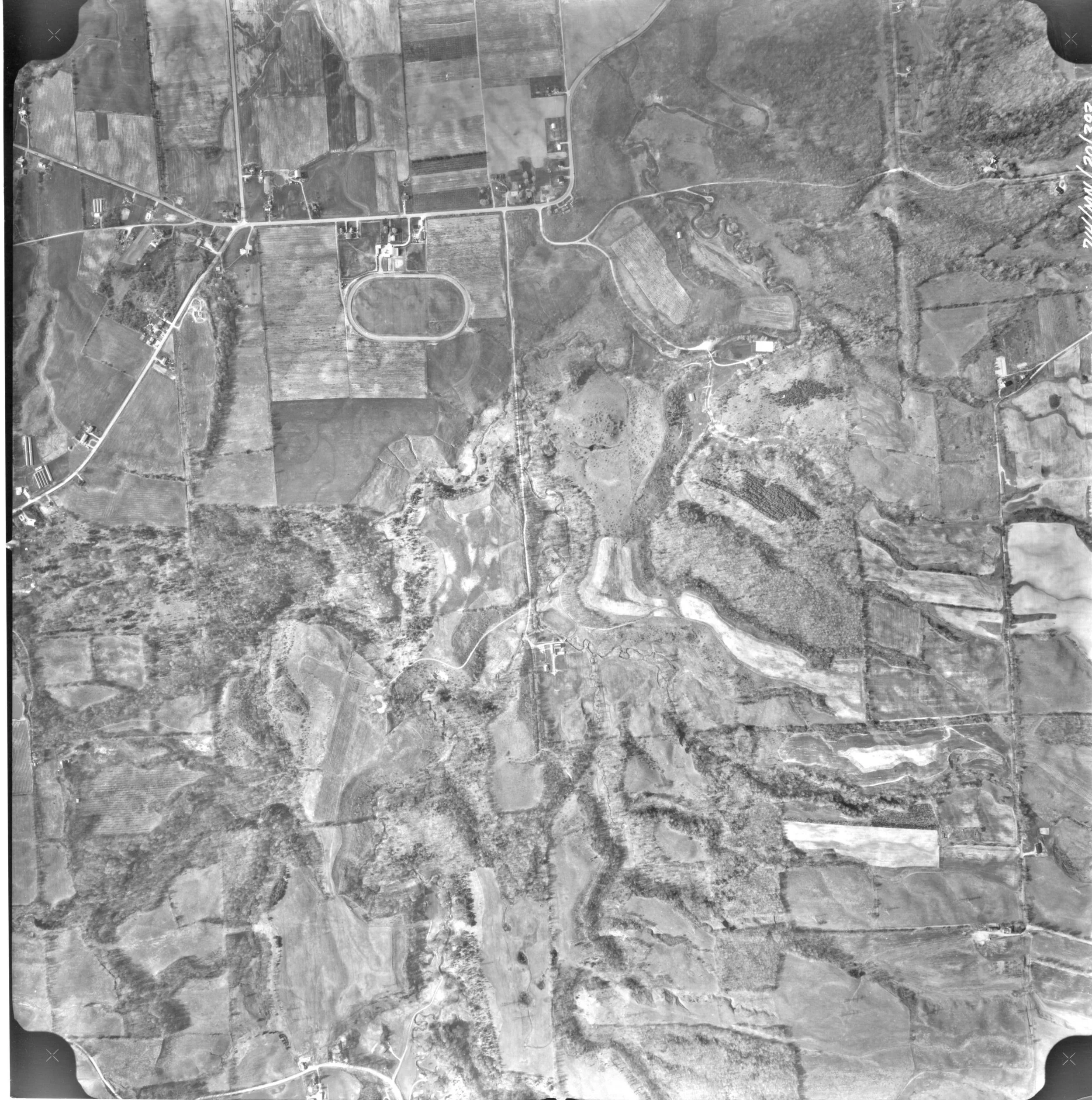
An aerial photo capturing the northern section of the Short Hills, 1971. Note the tracts of cultivated land now weaving through the Short Hills, attributed to advancements in agricultural machinery. Much of this area is now protected as part of Short Hills Provincial Park. J.D. Barnes Ltd., Surveyors, “Niagara Region Air Photos,” 1974. Digitized by MDGL, Brock University.
In fact, it seems that after two centuries of attempting to harness it, we’ve finally relented to the ruggedness and wilderness of the Short Hills. First established as a reserve in 1974, Short Hills Provincial Park is an assurance, rather, of protection and preservation. Remnants of settlement, industry, military interests, and dramatic raids have largely been grown over, and forgotten. Visitors to the park can find patches of now wild orchards, fence posts, and farm roads, and even abandoned agricultural equipment and old mill stones. And if you know where to look, you can even wander through remaining foundations of long destroyed mills and buildings. But I’ll let those secrets stay in the wilds of the Short Hills… for now.
Interested in learning more about the Short Hills, and especially seeing more maps? Attend an upcoming Secrets of the Short Hills Community Talk! The Brown Homestead will be presenting at the following locations:
Lincoln Pelham Public Library (Fonthill Branch) - Thursday, April 30, 2026 at 6:30 p.m.
Niagara-on-the-Lake Museum - Thursday, May 21, 2026 at 7:30 p.m.
Sara Nixon is a public historian and the Director of Community Engagement at The Brown Homestead. This article is her personal love letter to the Short Hills and its endless depths.
Footnotes
[1] David M. Sothers, “A Preliminary Report on an Archaeological Survey of Effingham Provincial Park,” Ontario Ministry of Natural Resources, Division of Parks, Thorold and Pelham Townships, County of Welland (June 1972): 1.
[2] Elaine Peebles, Resource Inventory Report : The History of the Short Hills Effingham Park Reserve (Toronto, Ont.: Ministry of Natural Resources, 1974): 9.
[3] Peebles, 13.
[4] The chert, which is an abrasive rock long used to make weapons like knives, spears and arrows, was located on a narrow ridge overlooking valleys on both sides, close to St. Johns area. That this “chipping station”, where tools would have been shaped and sharpened, was on a ridge and distanced from a body of water, meant the Indigenous people doing this work were hunter and gatherers. Sothers, “Effingham Provincial Park,” 2 -3.
[5] Ibid.
[6] Ibid.
[7] E.E. Brehault, “Changing Land Use in the Short Hills,” Thesis Submitted to Brock University Department of Geography (1968): 17.
[8] While we don’t have concrete statistics on agricultural production from these early years, we do know that at the time a small mill could usually grind from 4,000 bushels to 15,000 bushels of grain per year, while a larger one could grind up to 40,000 bushels per year. So, if 6 grist mills were operating - we can assume a generous swatch of the land was under cultivation. Peebles, 24.
[9] Andrea Klose, A History of Short Hills Provincial Park, St. Catharines, ON: Friends of Short Hills Park, 2024: 30.
[10] Pebbles, 70.